Fil:Taiwan relief location map.jpg

Sidans innehåll stöds inte på andra språk.
Från Wikivoyage, den fria resehandboken.

Originalfil(1 016 × 1 222 pixlar, filstorlek: 101 kbyte, MIME-typ: image/jpeg)

Den här filen är från Wikimedia Commons och kan användas av andra projekt. Beskrivningen på dess filbeskrivningssida där visas nedan.

Warning sign This file requires updating because: The earlier forms of this map did not extend a dotted-line around Dongyin, Lienchiang (Tungyin). The northern edge of this map ought to be moved up a little bit (in latitude) so that a dotted line encompassing Dongyin (Tungyin) can be clearly drawn and so that we can see a few of the islands north of Lienchiang County in Haidao Township, PRC. Example of a better map from The Economist: [1]. In doing so, you could add a timestamp to the file.
Please notify the uploader with {{subst:update-note|1=File:Taiwan relief location map.jpg|2=The earlier forms of this map did not extend a dotted-line around Dongyin, Lienchiang (Tungyin). The northern edge of this map ought to be moved up a little bit (in latitude) so that a dotted line encompassing Dongyin (Tungyin) can be clearly drawn and so that we can see a few of the islands north of Lienchiang County in Haidao Township, PRC. Example of a better map from The Economist: [2].}} ~~~~

Sammanfattning

Beskrivning
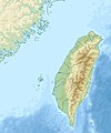
English: Relief location map of Taiwan.
  • Projection: Equirectangular projection, strechted by 110.0%.
  • Geographic limits of the map:
  • N: 26.4° N
  • S: 21.7° N
  • W: 118.0° E
  • E: 122.3° E
  • GMT projection: -JX17.204266666666665cd/20.68512992248063cd
  • GMT region: -R118.0/21.7/122.3/26.4r
  • GMT region for grdcut: -R118.0/21.7/122.3/26.4r
  • Relief: SRTM30plus.
  • Made with Natural Earth. Free vector and raster map data @ naturalearthdata.com.
Datum
Källa Eget arbete
Skapare Uwe Dedering

Licensiering

Jag, upphovsrättsinnehavaren av detta verk, publicerar härmed det under följande licenser:
w:sv:Creative Commons
erkännande dela lika
Denna fil har gjorts tillgänglig under licenserna Creative Commons Erkännande-DelaLika 3.0 Unported, 2.5 Generisk, 2.0 Generisk och 1.0 Generisk.
Du är fri:
  • att dela – att kopiera, distribuera och sända verket
  • att remixa – att skapa bearbetningar
På följande villkor:
  • erkännande – Du måste ge lämpligt erkännande, ange en länk till licensen och indikera om ändringar har gjorts. Du får göra det på ett lämpligt sätt, men inte på ett sätt som antyder att licensgivaren stödjer dig eller din användning.
  • dela lika – Om du remixar, transformerar eller bygger vidare på materialet måste du distribuera dina bidrag under samma eller en kompatibel licens som originalet.
GNU head Tillstånd ges att kopiera, distribuera och/eller modifiera detta dokument under villkoren i GNU Free Documentation License, Version 1.2 eller senare version publicerad av Free Software Foundation, utan oföränderliga avsnitt, framsidestexter eller baksidestexter. En kopia av licensen ingår i avsnittet GNU Free Documentation License.
Du får själv välja den licens du vill använda.

Bildtexter

Ingen bildtext har definierats

Objekt som porträtteras i den här filen

motiv

image/jpeg

Filhistorik

Klicka på ett datum/klockslag för att se filen som den såg ut då.

Datum/TidMiniatyrbildDimensionerAnvändareKommentar
nuvarande19 september 2019 kl. 16.01Miniatyrbild för versionen från den 19 september 2019 kl. 16.011 016 × 1 222 (101 kbyte)Geographyinitiativetemporary fix: extending the boundary out around Dongyin Township (as in China Fujian2 location map.svg and as in File:Nationalist China - administrative divisons. LOC 2007633622.jpg)
3 augusti 2019 kl. 19.09Miniatyrbild för versionen från den 3 augusti 2019 kl. 19.091 016 × 1 222 (537 kbyte)NordNordWestborder corrections
3 augusti 2019 kl. 03.51Miniatyrbild för versionen från den 3 augusti 2019 kl. 03.511 016 × 1 222 (96 kbyte)GeographyinitiativeProposed removal of three dashes (markers of the approximate PRC/ROC maritime boundary) which seemed to put Dadan Island, Erdan Island and Binlang Islet (檳榔嶼) outside the territory of Kinmen County, Taiwan/ROC. This is not the optimal form of the map, but is merely a quick removal of incorrect information. In the optimal situation, the line needs to be redrawn in the correct location, but I don't have the technical skill to produce such a map. (Basis: [http://ws.mac.gov.tw/001/Upload/OldFile/...
3 augusti 2019 kl. 02.30Miniatyrbild för versionen från den 3 augusti 2019 kl. 02.301 016 × 1 222 (96 kbyte)GeographyinitiativeProposed removal of two dashes (markers of the approximate PRC/ROC maritime boundary) which seemed to put {{w|Dadan Island}} and {{w|Erdan Island}} outside the territory of {{w|Kinmen County}}, Taiwan/ROC.
28 december 2010 kl. 19.22Miniatyrbild för versionen från den 28 december 2010 kl. 19.221 016 × 1 222 (452 kbyte)Uwe Dedering{{Information |Description={{en|1=Relief location map of Taiwan. * Projection: Equirectangular projection, strechted by 110.0%. * Geographic limits of the map: :* N: 26.4° N :* S: 21.7° N :* W: 118.0° E :* E: 122.3° E * GMT projection: -JX17.204266666

Följande sidor länkar till den här bilden:

Global filanvändning

Följande andra wikier använder denna fil:

Visa mer globalt användande av denna fil.

Metadata